
You Will Get Consultation On Geographic Information System (GIS) Mapping

Share
Description of Consultation
Our experience for more than a decade in Geographical Mapping is pushing us to become a well known and reputed service provider in this field. We endeavor to provide best quality output to companies requiring help in getting spatial information mapped and interpreted. At R S Datum, our expertise have depth of knowledge of data mapping, feature extraction or compilation, management of information and integrating enterprises through GIS expertise.
We try our best to help you obtaining the best type of Digital Imagery, whether it is Arial Photography of Satellite Imagery. Our services include Land Cover Mapping, Utility Mapping, Tax Parcel Mapping, Thematic Mapping, Topographic Mapping, Contour Mapping, Cartographic Mapping, Road Network, Topo Sheets Analysis, Mapping for street navigation system, Ortho photographs rectification, Flood insurance rate mapping, Contour Digitization for Terrain Analysis, Soil and land use for agriculture, wetlands, airport, highway and Rail Mapping.
Our GIS Mapping services help in these areas: Forestry, Water management, Telecom, Power Distribution, Gas and Oil pipeline, Agriculture, Governmental schemes for developments for different Provinces and regions etc.
Inputs which are generally accepted: Geo TIFF, JPEG2000, MrSID, netCDR,
General outputs required by our global clientele: AutoCAD DXF, Cartesian Coordinate System(XYZ), Digital Line Graph (DLG), EsriTIN, GeoMedia, ISFC, MapInfo TAB format & The most popular these days- SHAPE File, Spatial data file, Vector Product Format (VPF), World file e.g. JPEG, BMP etc., Dual Independent Map Encoding (DIME) -Ob, Well known text (WKT)
Grid formats for elevation: GTOPO30, DTED, GeoTIFF, SDTS.
SOFTWARE USED: AUTOCAD, ERDAS IMAGINE, ARCGIS, MAPINFO, GLOBAL MAPPER.
What you will get from meeting with me
You Will Get Consultation On Geographic Information System (GIS) Mapping
Things I can do. Things I can offer
You Will Get Consultation On Geographic Information System (GIS) Mapping
My Classification
Energy Service Company,Engineering Company,Consulting Company,Contractor,Sub-Contractor
My Experience Level
Senior

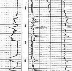
About Well Log Digitizing
Since established in 2000, Well Log Digitizing has been providing its services of vectorizing & digitizing the different kind of analog images mainly in the field of Well Log Data. All hardcopy of well log data which may be in the mod of paper, microfiche, films etc. are converted to industry standard interpretation ready electronic vector format. Well log digitizing is one of the leading technologies we utilize for the geophysical community by using the latest automatic and manual digitizing technology.
Ratings & Reviews
No Ratings & Reviews given yet..
More Consultations From Well Log Digitizing


You Will Get Consultation On Conversion of Old Gamma Logs
Well Log Digitizing
100/hr

You Will Get Consultation On Image Splicing and Editing
Well Log Digitizing
100/hr
Similar Consultations (Recommended consultations)


Daly & Inamdar, Advocates
500/hr


Amros Corporation
3000/hr


Frederick Geosciences, LLC
1000/hr


Southwest Pinnacle Exploration Limited
250/hr