
Automated Seismics
Santa Clarita, California, United States
Automated Seismics
!


Provider of services for surface-based passive seismic data acquisition and processing.
About Automated Seismics
Automated Seismics was founded by 3 Caltech graduates with the aim of providing vertically-integrated passive seismic monitoring services for the energy industry from data acquisition to processing.
Automated Seismics provides services for surface-based passive seismic data acquisition and processing. Enabled by our new WiFi-equipped and solar-powered nodes, we can deliver real-time data for both short and long term projects with an array of 1000+ nodes. We specialize in processing data to track microseismic activity across broad applications from hydraulic fracturing to geothermal energy.
Description of Services
Services:
1. Seismic Data Acquisition
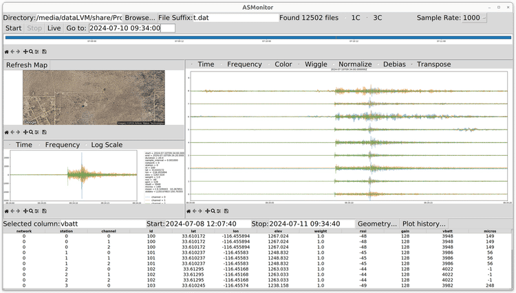
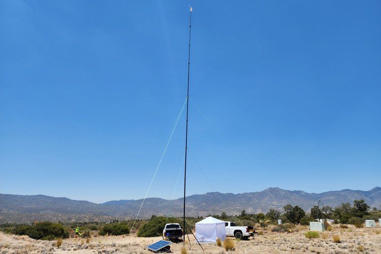
AS-Monitor: Real-Time Seismic Data Acquisition System
Nodes have flexible 1C or 3C configurations with internal or external geophones
Automated Seismics provides services for short and long-term passive seismic monitoring using the AS-Monitor real-time wireless seismic data acquisition system.
- 1C or 3C continuous seismic data acquisition with arrays of 1000+ nodes
- Real-time wireless data transmission via WiFi
- Solar powered for long-term and permanent deployments
- Software for real-time data visualization and quality control
- Autonomous operation
- Flexible network geometry able to accommodate terrain and access restrictions
We offer rapid deployment across the contiguous US in all weather conditions. With real-time monitoring, any data acquisition faults are addressed promptly. Microseismic processing can also be conducted in tandem with the acquisition.
System Components
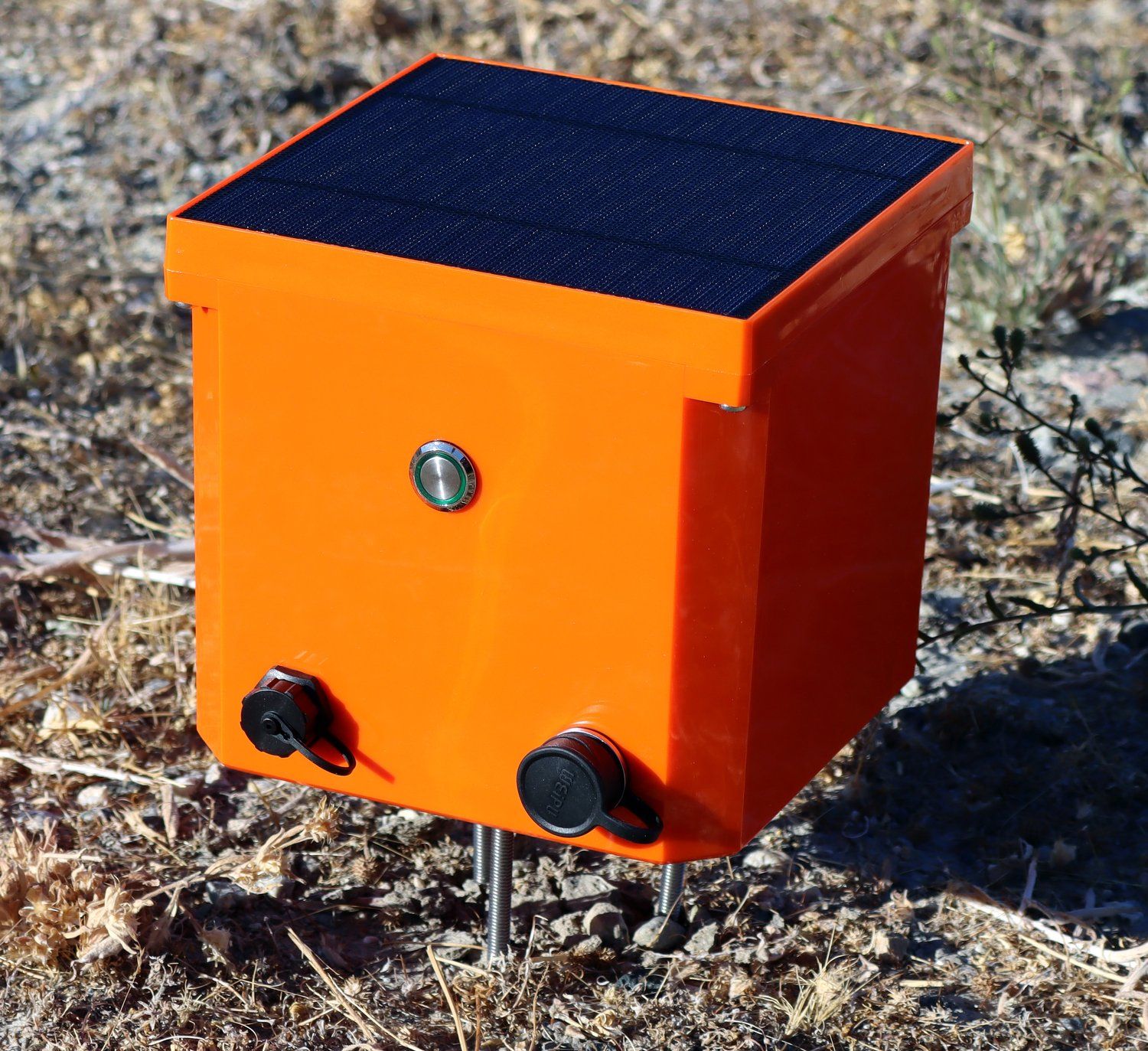
A single autonomous node deployed on 3 stakes
-
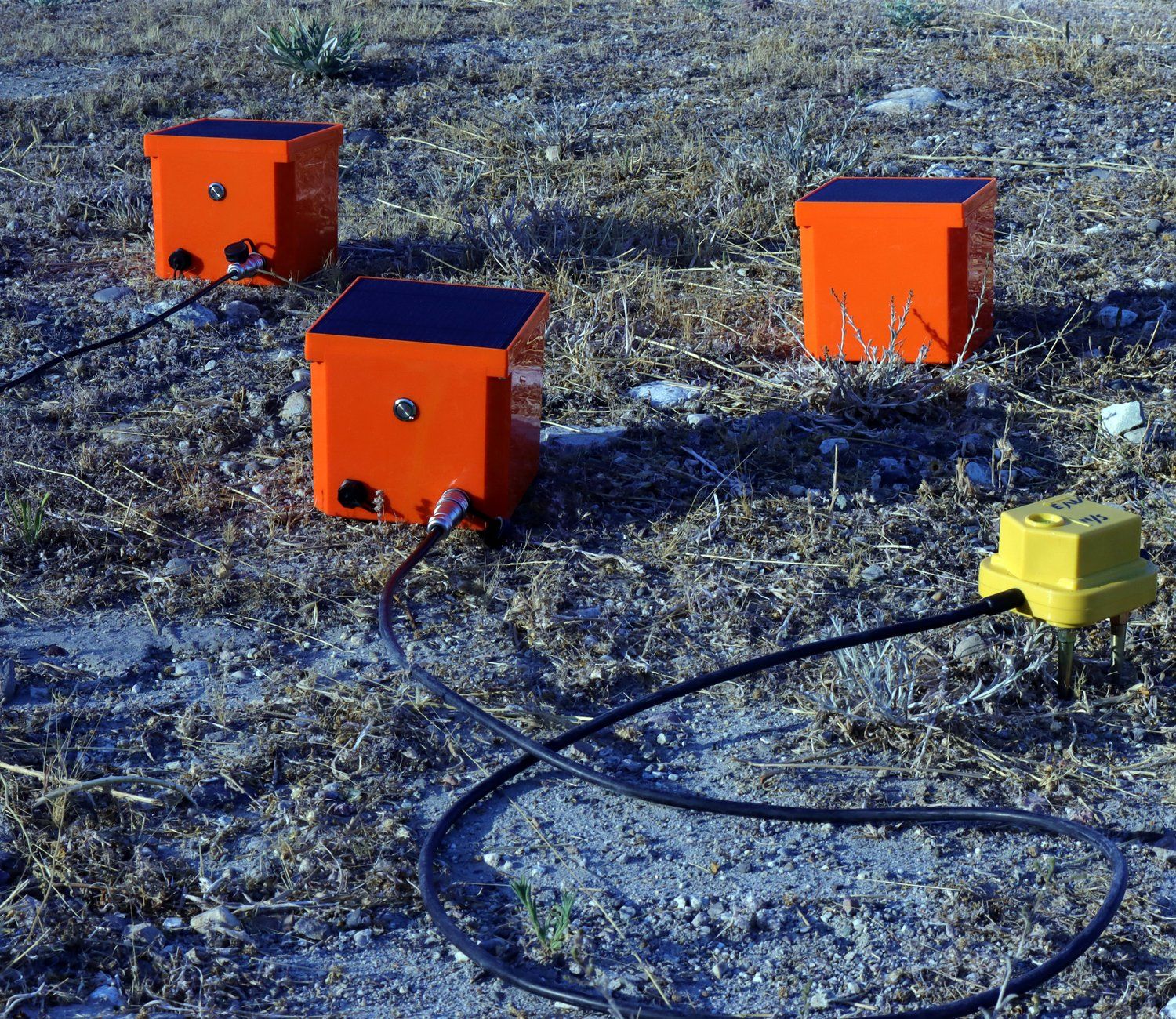
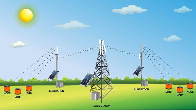
Node: Each fully autonomous node continuously digitizes seismic data from an internal geophone or externally connected geophone string. An onboard GPS receiver provides accurate timing and location information. Encrypted data is transmitted by WiFi at 20 second intervals and is also backed up on internal storage. An integrated solar panel automatically recharges the node’s batteries when sunlight is available.
-
Substation: A substation contains a WiFi access point that communicates with groups of up to 50 1C nodes (or 18 3C nodes) over an area of up to 0.5 sq. km. Multiple substations can be deployed to relay data from an array of nodes over a wide survey area to the base station.
-
Base Station: The base station collects data from every node via a WiFi bridge with each substation up to 15 km away. A computer saves the data from each node to disk and runs software for real-time seismic data visualization and quality control. Any data lost during transmission is automatically retransmitted in the next 20 second interval. At the end of data acquisition any remaining missing data can be recovered from each node. The data is also accessible in real-time over the internet in SEG-Y or other standard data formats.
2. Surface Microseismic Monitoring
Automated Seismics provides services for surface-based microseismic analysis. We can analyze data collected with our AS-Monitor real-time seismic data acquisition system or reprocess data collected from other systems. We specialize in leveraging data from large arrays with 1000+ channels to detect and locate microseismic events in noisy environments. Our aim is to provide high quality microseismic event catalogs ready to integrate with other field data and improve the understanding of your reservoir.
Applications
In any application where fluids are injected into the subsurface, imperceptible earthquakes called microseismic events result from slip on rock discontinuities such as faults, fractures, or bedding planes as the stress field changes.
Example use cases throughout the energy industry include:
- Hydraulic fracturing/unconventional oil and gas
- Enhanced geothermal systems
- Wastewater injection
- Carbon sequestration and enhanced oil recovery
- Mining
Microseismic monitoring is highly valuable in understanding:
- Geometry and evolution of fracture networks
- Location of faults
- Fluid flow pathways
- Stress state of a reservoir
- Potential for larger, hazardous induced earthquakes
Advantages
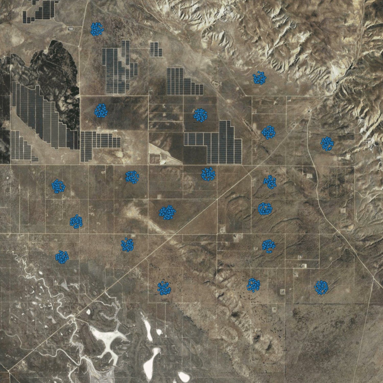
Potential design of a surface array with clusters of geophones to accommodate land access.
Despite the noisy character of surface-based microseismic data, it has several advantages compared to downhole geophone or fiber optic data.
-
Cost-effectiveness: Surface array deployment requires less infrastructure and equipment compared to downhole sensors.
-
Flexibility: The geometry and size of a surface array can be adapted based on the layout of wells, project budget, permitting requirements, and local noise sources such as roads and buildings (see right).
-
Risk reduction: Surface arrays avoid the risks of deployment in harsh borehole conditions and may be quickly serviced when faults occur.
-
Broad area coverage: A surface array has uniform coverage over many square kilometers, which is particularly important when monitoring a multi-well project and accurate epicenter locations are essential. It also enables the focal mechanism (fault plane orientation and direction of slip) to be estimated from the radiation pattern of each event.
Processing
The most up-to-date data processing techniques and our own purpose-built software is used to extract the most out of noisy data.
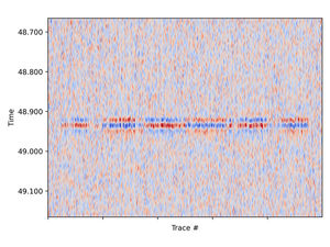
Top: Low-noise microseismic event data (left) and source scanning location likelihood map (right).
Bottom: Microseismic event (left) with 10x noise as the top and a source scanning map (right) showing the event is still well localized.
-
Source scanning event detection: A source scanning algorithm is used to detect and locate events even when data is too noisy to see microseismic signals in individual traces (see right).
-
Coherent noise attenuation: When channels are densely spaced, spatial noise filters are available to reduce coherent noise from surface waves.
-
Statics correction and velocity model calibration: Perforation shots are utilized to reduce velocity model uncertainties and accurately locate the depth of all events.
-
3D Velocity Models: In structurally complex areas, 3D velocity models beyond a layer cake approximation can be used to locate events more accurately.
-
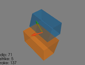
Moment tensor inversion: The focal mechanism is determined from the radiation pattern of each event (see below).
Data Products
The final product of microseismic monitoring is a catalog of properties for every detected microseismic event.
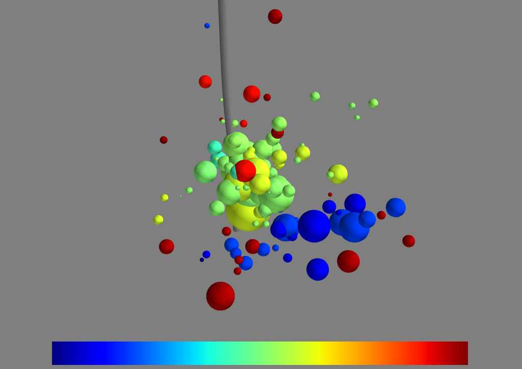
3D visualization of microseismic events following injection in a vertical well colored by time and sized by magnitude.
-
Event Time: Correlate seismic activity with the fluid pumping schedule.
-
Event XYZ Location: Constrain the shape of the stimulated rock volume, identify interference between wells, and locate natural faults.
-
Moment Magnitude: Determine the rate of earthquakes by size and meet regulatory requirements.
-
Moment Tensor and focal mechanism: The orientation of fault planes and direction of slip can provide valuable information on natural or induced fractures.
-
Stage and well attributes: For hydraulic fracturing projects, events are tagged by well and stage number. Attributes such as distance to the perforation cluster and time from pumping start calculated for well interference and stage performance studies.
All event data is collated into a 3D animation to visualize the spatial distribution of microseismic activity over time. We can also work with you directly to integrate well log, pumping, 3D seismic, and fiber optic data to get the most out of your microseismic data.