
SAExploration
Stafford, Texas, United States
SAExploration
!


Provider of full range of geophysical ground acquisition services.
About SAExploration
SAExploration is a global provider of geophysical ground acquisition services, including everything from design, drilling, recording, and in-field quality control. SAE’s expertise spans various terrains, from land to marine environments, with specialized capabilities in ocean bottom seismic (OBS) operations.
Safety and environmental stewardship are central to SAExploration’s operations. They prioritize collecting high-quality data while ensuring the safety and well-being of their personnel and minimizing environmental impact. Collaboration with local communities and landowners is integral to their approach, emphasizing respect for property and leaving minimal trace of their activities.
SAExploration emphasizes the use of progressive technologies tailored to meet the specific requirements of each project. Our technical experts advise on utilizing wireless onshore or ocean bottom nodal systems and other advanced equipment to optimize results. The company’s fleet includes cutting-edge marine vessels and specialized equipment like the onSEIS™ synchronized impulsive source vehicle.
Founded in 2006, SAExploration has evolved to the changing landscape of the upstream oil and gas industry. They prioritize fostering relationships based on mutual trust and understanding, aiming to optimize project planning and management while ensuring a safe and healthy work environment for employees worldwide.
Description of Services
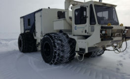
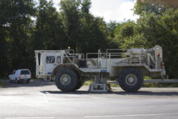
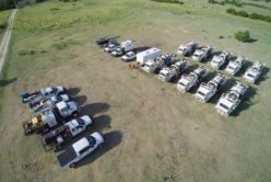
Land Services
- Logistics
At SAExploration, we bring decades of meaningful and specialized experience derived from our work in a variety of unique and logistically challenging environments worldwide. We have an exceptional track record in difficult terrain and heavily cultivated areas. In all environments and in all professional settings, we strive to reduce the risk for all parties involved where you are acquiring a client’s project by recognizing and respecting that local communities are interested parties in the project.
PROGRAM DESIGN
The comprehensive planning and design of a geophysical program is critical, complex and an area in which SAExploration excels. Our team of experts brings years of experience and uses the latest software to ensure that the most efficient design is used to meet geophysical objectives.
PLANNING AND PERMIT AND SOCIAL RELATIONSHIP
Any successful geophysical program begins with a comprehensive project plan. At SAExploration, our mission is to help our clients reduce the risk and cost of exploration by collaborating to develop solid strategies from scratch, regardless of scope, geographic region or technical challenge.
LOGISTICS
Our teams excel in resource planning and logistics to ensure the best possible performance. We pay special attention to details, including budget, time and equipment requirements to make the best possible geophysical survey, maintain high standards and deliver superior data.
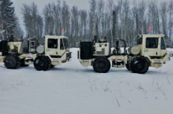
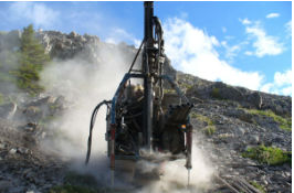
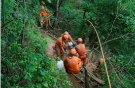
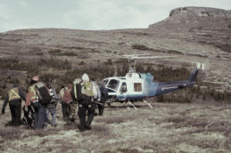
- Dynamite and Heliportable
At SAExploration, we bring decades of significant and specialized expertise borne from our work in a variety of unique and logistically challenging environments around the world. We have an exceptional track record across harsh terrain and heavily cultured areas. In all environments and in every operation, we strive to reduce risk to all parties involved where a client’s project is being acquired by recognizing and respecting that both the local communities are important stakeholders in the project.
SAE has further proven expertise with remote heliportable operations. Flying more than 30,000 hours incident free over the past four years with proven equipment, techniques and a focus on training to ensure project success.
Our teams share best practices across all regions to ensure maximum efficiency and consistent quality for our client projects. Most key SAExploration team members are cross-trained on different projects in different regions, enabling them to bring a unique depth and diversity of experience to a given project. We are widely recognized as one of the most knowledgeable and innovative geophysical contractors in the world.
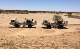
- Vibroseis
At SAExploration, we bring decades of significant and specialized expertise borne from our work in a variety of unique and logistically challenging environments around the world. We have an exceptional track record across harsh terrain and heavily cultured areas. In all environments and in every operation, we strive to reduce risk to all parties involved where a client’s project is being acquired by recognizing and respecting that both the local communities are important stakeholders in the project.
SAExploration has been on the leading edge of High Production Vibroseismic acquisition. With our fleet of vibrators ranging from 15,000 to 80,000 pounds and using our Source Driven Shooting techniques we can average more than 10,000 VPs day. Combining this with the advancements in nodal (autonomous sensing and recording) technologies we have successfully recorded programs with trace densities exceeding five million traces/km2, creating true value for our customers.
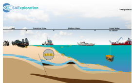
- Transition Zone
In these areas where land and water join, the elements of both onshore and offshore surveying techniques are employed. Transition-zone seismic data acquisition is similar to shallow-water applications in that both hydrophones and geophones are deployed with small, shallow-draft vessels and our shallow-draft source vessels and acoustic source would be configured to address depth variations typical in these shallow-water settings.
Due these shallower water depths, the use of many small handling vessels and manual labor are required to deploy and retrieve receivers. For these reasons, extensive survey planning is required to ensure a cost-effective operation so that all aspects are orchestrated in a safe and homogenous manner.
In transition-zone areas consisting of areas with an extended beach, swamp or marsh, explosives can be applied as an acoustic source to contribute to image offshore or combining the deployment of land sensors are also a possibility to extend imaging onshore through the transition-zone. SAExploration has a vast amount of experience in these types of environments which will translate to a savings in both time and money.
- Land Technology
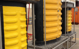
The SAE Marine Vibrator is a towable marine source that generates seismic energy equivalent to airguns, at significantly reduced sound pressure levels, and at frequencies below the hearing range of most marine species.
The Marine Vibrator subarray consists of two Triton vibrators and one lower frequency Subtone, each with different response characteristics and resonant frequencies. Advanced controller systems can enable precise acoustic output, while providing real-time feedback to ensure high levels of acoustic quality control. Marine Vibrator is designed for water depths as shallow as one-meter, delivering performance and reliability in challenging transition-zones, lakes and shallow-water OBN surveys.
- Bandwidth control enables overall lower signal level output.
- Multiple-second sweep duration markedly reduces instantaneous sound pressure levels.
- Meets updated NOAA guidelines for TTS and PTS.


What we do
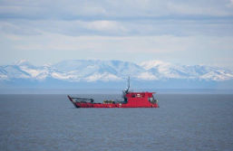
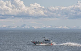
Marine Services
- Transition Zone
In these areas where land and water join, the elements of both onshore and offshore surveying techniques are employed. Transition-zone seismic data acquisition is similar to shallow-water applications in that both hydrophones and geophones are deployed with small, purposely built shallow-draft vessels and our specialized source vessels and the acoustic source would be configured to address the depth variations typical in these shallow-water settings.
Due these shallower water depths, the use of many small handling vessels and manual labor are required to deploy and retrieve receivers. For these reasons, extensive survey planning is required to ensure a cost-effective operation so that all aspects are orchestrated in a safe and homogenous manner.
In transition-zone areas consisting of areas with an extended beach, swamp or marsh, explosives can be applied as an acoustic source to contribute to image offshore or combining the deployment of land sensors are also a possibility to extend imaging onshore through the transition-zone. SAExploration has a vast amount of experience in these types of environments which will translate to a savings in both time and money.
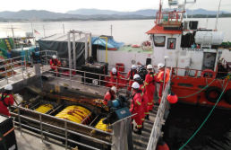
- Shallow Water
Our expertise in multiple shallow-water settings, prepares our team members with tools, training and methodologies designed to meet a vast spectrum of surveying requirements and operating safely and respectful of the environment.
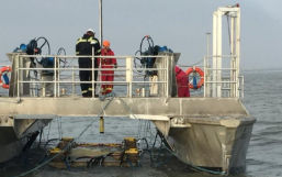
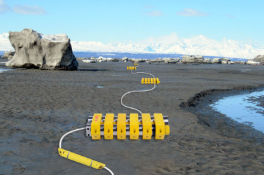
For the typical offshore OBN survey, tuned airgun arrays, which release high-pressure compressed air into the water column, are used as the acoustic energy source and a quantity of OBN units consisting of 4-components (hydrophone + 3 orthogonal geophones) are deployed to record the minimum survey offset requirements.
Typically, these types of surveys require several thousand nodes because these areas are either, sizeable in scope or the image requires denser receiver spatial sampling, or both, so the nodes are typically deployed and recovered tethered to a high-strength synthetic rope (NOAR, Node-On-A-Rope) for handling efficiency purposes. For additional crew efficiency gains, multiple specialized node handling vessels and/or multiple purposed-built source vessels can be incorporated into the operation.
In areas with deeper waters that comprise of production facilities or environmentally sensitive areas, remotely operated vehicles can be also utilized for a more precise and safer deployment and recovery of the ocean bottom nodes. In other shallow-water regions where shallow-water shoals or islands exist, it may be necessary to incorporate SAExploration’s transition-zone techniques to achieve the required image and objectives.
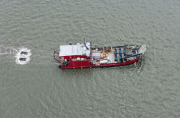
- Deep Water
In the deep-water environments, SAExploration configures a typical survey crew with a single certified DP-2 classed Construction Support Vessel (CSV) staffed and equipped for twin work-class ROV operations, which is supplemented with an industry seismic source vessel configured and tuned to specific source signature requirements. All vessels will comply with industry and customer HSE standards and are fully manned with highly experienced crew. These vessels are supplied survey-ready to meet geophysical industry standards for 4D-Grade data recording.
In all cases, each work-class ROV is supplemented with the most advanced survey instrumentation for extremely accurate and precise subsea positioning of each OBN unit deployed. Twin ROVs enable multiple receiver line deployment and recovery during a single vessel traverse. The seismic source vessel or vessels are equipped for either single, dual or triple source firing techniques and all arrays can be additionally outfitted with the latest near-field hydrophones and steering capabilities for controlled source positioning.
A standalone OBN survey will compliment any legacy seismic dataset or OBN techniques can be deployed concurrently using the seismic source during a towed hydrophone array seismic acquisition to capture near-offsets with nodes surrounding surface obstacles (natural or man-made) or sparse receiver design specifically to capture extended-offsets and azimuths for improved subsurface velocity definition for Full-Waveform Inversion techniques, augmenting the towed-array image.
Our crews are commonly equipped with additional oceanographic instrumentation such as; Pressure-Inverted Echo Sounder (PIES), Sound Velocity, CTD, Current and/or Tide instruments to gather a variety of Metocean data measurements.
- Marine Technology
The SAE Marine Vibrator is a towable marine source that generates seismic energy equivalent to airguns, at significantly reduced sound pressure levels, and at frequencies below the hearing range of most marine species.
The Marine Vibrator subarray consists of two Triton vibrators and one lower frequency Subtone, each with different response characteristics and resonant frequencies. Advanced controller systems can enable precise acoustic output, while providing real-time feedback to ensure high levels of acoustic quality control. Marine Vibrator is designed for water depths as shallow as one-meter, delivering performance and reliability in challenging transition-zones, lakes and shallow-water OBN surveys.
- Bandwidth control enables overall lower signal level output.
- Multiple-second sweep duration markedly reduces instantaneous sound pressure levels.
- Meets updated NOAA guidelines for TTS and PTS.
- Marine Geophysical Acquisition Services
For more than 10 years, SAExploration have developed a comprehensive acquisition portfolio exploiting the most advanced Ocean Bottom Node (OBN) technologies that are required for enhanced reservoir identification, delineation, characterization and monitoring, whilst delivering the most sophisticated subsurface data in the geophysical industry today.
SAExploration provides safe, accurate, eco-responsible and seamless full-wavefield geophysical surveying services for all aquatic environments; transition-zone (surf and tidal zones); shallow-water and deep-water. Our commitment to an uncompromising HSE program, offers decades of knowledge and expertise garnered from operating in unique and logistically challenging environments all around the world.
SAExploration excels in the methods and techniques of acquiring 2D, 3D and 4D full-azimuth and full-wavefield geophysical datasets that will meet or exceed your subsurface imaging requirements by extending data bandwidth with improved signal-to-noise performance coupled with the collection of data rich with increased offsets and azimuths through the appropriate design and implementation of these nodal technologies. 4D-Grade data can be acquired with either single or one-component (1C), two-component (2C) or four-component (4C) sensing technology, in water depths from 1 to 3,450 meters.
Gained by OBN system and survey design flexibilities, it is very common for the ultimate OBN survey design be constructed and tuned to address multiple geological and geophysical objectives during the same survey, some of which are;
- New prospect identification, de-risking and mitigate uncertainty with both new and existing targets;
- Better recorded signal through imaging through acoustic shadowing zones (gas, salt, carbonates, etc.) as a result of near-surface and over-burden geologic properties, geo-hazards or shallow elements such as mud volcanos, shallow channels or shallow gas reservoirs, which acoustically mask the targeted deep reservoirs;
- Subsurface velocity definition for full-waveform inversion;
- Better illumination of subsurface fault patterns and fractures through improved spatial data sampling and resolution;
-
Field (Asset) development and EOR (4D)
- Improved structural imaging and seismic characterization to the reservoir’s depth;
- Well-planning development and well-placement optimization;
- Full data bandwidth with enriched high-frequency and improved low-frequency data content below 8 hertz;
- Better illumination of the reservoir structure, including below salt and/or steep flanks;
- Better understanding of the reservoir compartmentalization and lateral connectivity;
- Identification of undrained hydrocarbon compartments and Gas/Water contacts;
- Improved understanding of the prospect’s geologic properties.