
Z-Terra Inc
Houston, Texas, United States
Z-Terra Inc
!


Provider of integrated enterprise seismic imaging software and service solutions for the upstream oil and gas industry.
About Z-Terra Inc
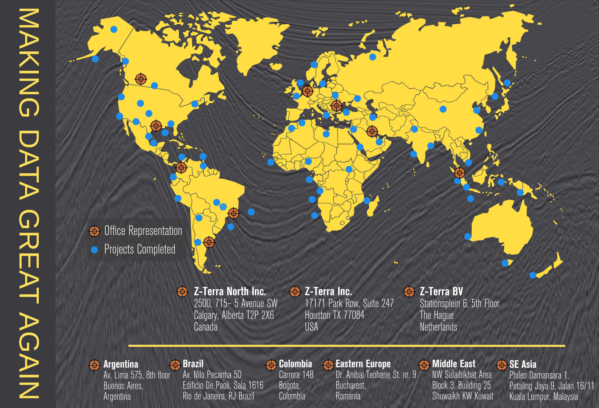
Z-Terra is a leading edge provider of integrated enterprise seismic imaging software and service solutions for the upstream oil and gas industry. We develop a suite of interactive depth imaging and velocity model building software products designed to be the fastest and most accurate depth imaging solutions in the industry. Services. Software. Solutions. Big Data Experts.
Z-Terra provides software and services for the upstream oil and gas industry. Our software helps oil and gas companies visualize 3-D earth structures and reduce the drilling risk associated with oil and gas exploration from ever more challenging plays. Our vision is to develop the fastest depth processing system in the industry and reduce turnaround time on large seismic projects from 6-8 months to 1 month.
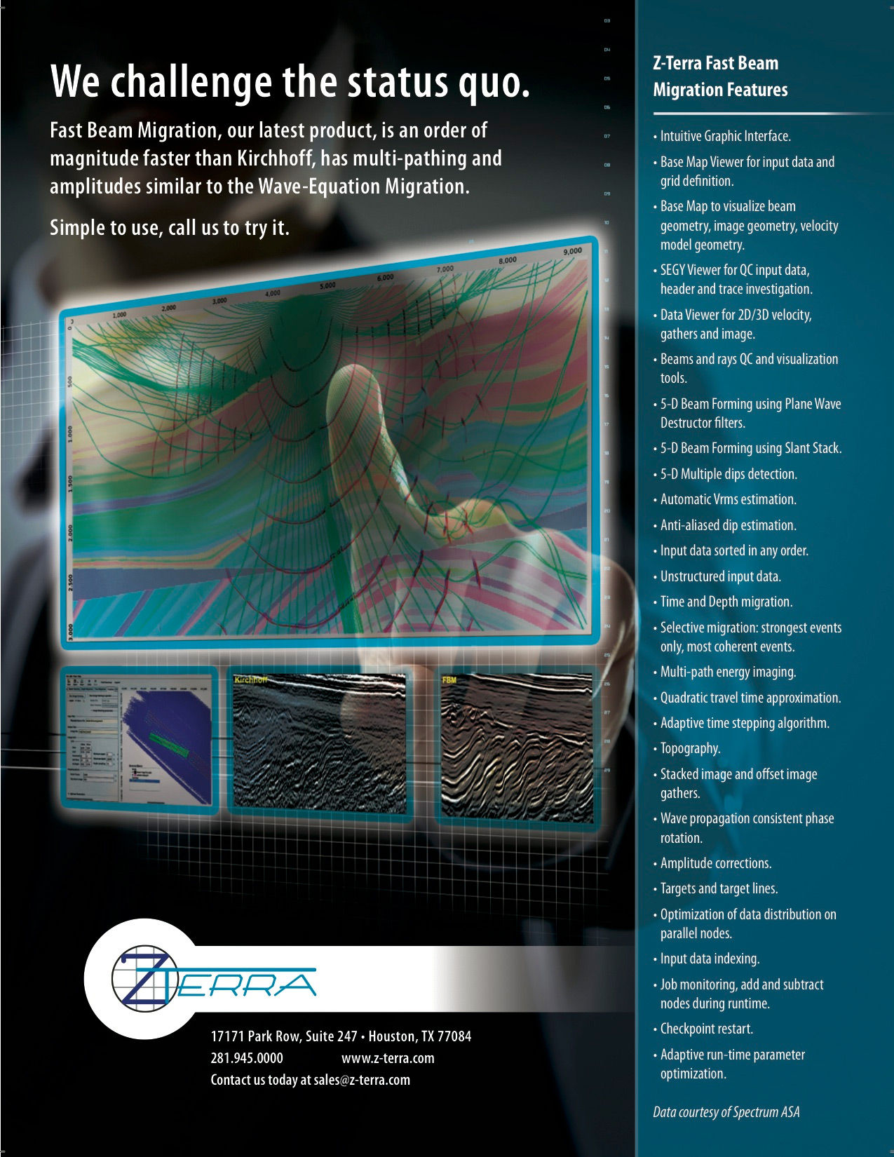
We believe in challenging the industry status quo in everything we do. We make our software faster, simpler to use, and more user-friendly than anyone else’s in the industry.
Core Technology
Z-Terra develops a suite of interactive depth imaging and velocity model building software products designed to be the fastest and most accurate depth imaging solutions. Our processing system is based on a combination of Smart Migrations™ (ultra-fast imaging algorithms that allow for very fast imaging iterations — on the order of minutes for imaging thousands of square kilometers) and very fast migration velocity analysis tools (including wide-azimuth tomography) within an optimally designed workflow.
One member of the Smart Migrations™ family is the Fast Beam Migration, a super-efficient algorithm that is on average 100 times faster than the industry standard Kirchhoff depth migration.
The Wide Azimuth Tomography using Extended Gathers is a novel innovation in the field of migration velocity analysis. All the imaging and tomographic updates are instrumented to handle VTI and TTI anisotropy.
Description of Services
Z-Terra provides software and full geophysical services from data processing to seismic interpretations for the upstream oil and gas industry.
How Z-Terra services will benefit you
Fast Results
We offer the fastest depth processing system in the industry. This will reduce the turnaround time on large seismic projects from 6-8 months to 1 month.
Geoscience Expertise
With our extensive experience in a wide range of complex velocity and geologic environments, we are able to deliver high-resolution images of the earth’s subsurface and reveal complex structural and stratigraphic details.
Close communication
We continuously communicate and collaborate with each client throughout their project’s workflow in order to achieve optimally desirable results.
Trust our award-winning team to complete your project. Our team has experience processing large seismic surveys from all major sedimentary basins.
a) Data Processing
Z-Terra offers full service geophysical data processing, from time preprocessing to advanced depth imaging for a variety of geological environments with workflows individually customized to each dataset. Our workflows are designed to handle surveys of any size, from small 2-D projects to multiple merged large 3-D projects, and are designed to handle any acquisition type (land, transition, or marine) in challenging overthrust regimes (e.g., salt flanks, subsalt, fault shadows, and small fracture fields in thin unconventional shale plays) or in the presence of anhydrites, basalt, and volcanic rocks.
Trust in Our Geoscientific Expertise
Z-Terra’s experts have extensive 3-D time and depth imaging experience in a wide range of complex velocity and geologic regimes and regularly employ the following:
- Industry-standard refraction modeling to assure effective near surface control that is essential in removing shallow distortions allowing for correct subsurface depth imaging
- An integrated 3-D PSTM and PSDM velocity modeling toolbox and robust 3-D imaging algorithms in order to define an accurate 3-D migration velocity model
- A large proprietary toolbox of depth imaging solutions including Kirchhoff depth migration, Diffraction Imaging, Fast Beam Migration (FBM), wave-equation migration (WEM), and reverse-time migration (RTM)
- Proprietary software for integrated velocity model building employing various geology-specific migration velocity analysis update strategies (e.g., anisotropic wide-azimuth tomography) performed on Kirchhoff and FBM offset and angle gathers; WEM and RTM angle gathers: and Kirchhoff, FBM, WEM, and RTM extended gathers
- Integration of geologic and non-seismic data sources into velocity modeling
- Intensive QC processes and client collaboration at all stages
- Industry-leading technical expertise from beginning to end
- Flexible resources to meet the challenges created by technologically complex projects
Build Solid Project Foundations
- Near surface travel-time distortion removal
Z-Terra will assure an accurate 3-D solution to mitigate long wavelength near-surface effects. Our approach removes both large and small scale near surface travel-time distortions providing confidence that the subsurface imaging can then be executed accurately.Noise Elimination
Source generated direct and scattered ground-roll noise and/or air blast energy are expected to degrade existing data in the area. Z-Terra’s proprietary noise attenuation methodology effectively attack these noises in the most relevant data domains with the most appropriate attenuation techniques.Shallow Data Continuity
The shallow levels of the 3-D datasets and the offset/fold relationships of the 3-D data can be addressed if there is limited consistent trace contributions at these levels. Z-Terra’s advanced 3-D trace interpolation methodologies may be used to provide greater consistency at these shallow levels to permit a best focused shallow 3-D image.Survey Merging
We perform seamless phase and amplitude matching of multiple adjacent surveys. In order to effectively merge the surveys, we select one survey as the “master” survey and focus on several key considerations:- Accurate geometry information
- Consistent binning to a common grid
- Amplitude and phase matching
- 3-D consistent processes
- Consistent near-surface control
First break picking of each survey to a common datum with a common replacement velocity after each iteration allows for an area-consistent near-surface model to be developed as a foundation for surface-consistent 3-D reflection residual statics later in the processing flow.
b) Depth Imaging
Depth imaging is the main seismic imaging tool in complex geologic areas where large lateral velocity variations, salt bodies, folded sedimentary layers, or faulted structures are present. The presence of complex geological structures renders most time processing assumptions invalid and time processing results inaccurate. A careful application of 3-D prestack depth imaging accurately delineates geological structures and improves oil-and-gas reservoir characterization. Accurate depth imaging also improves the risk assessment, helps operators improve drilling success rates, and decreases the costs of exploratory drilling and failed secondary recovery injection projects.
Z-Terra’s high-quality depth imaging has four main components:
- State-of-the-art imaging algorithms
- Accurate and fast anisotropic velocity model analysis and velocity model building software
- Multidimensional multivolume data analysis and visualization
- Fast and accurate simulation and data modeling algorithms
c) Diffraction Imaging
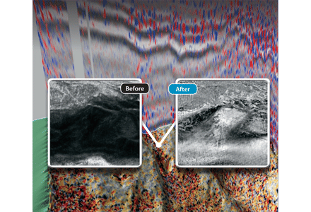
Z-Terra Diffraction Imaging is a revolution in super-resolution imaging for clastic and carbonate reservoirs as well as for shale resource plays, offering the highest resolution imaging and mapping of both structural and stratigraphic discontinuities and sub-wavelength features.
Correct identification of geological discontinuities is a salient challenge in the interpretation of seismic data. Diffraction imaging can be used to create a high resolution 3-D volume identifying small scale faults, pinch-outs, salt flanks, reflector unconformities or, in general, any small objects whose spatial extent is less than the seismic wavelength. This volume can be used in conjunction with the structural image from depth migration to deliver a high-precision interpretation of the structural details. 3-D diffraction imaging volumes can be used to identify and visualize the distribution of faults in unconventional shales, automatically delineate salt flanks, or uncover the full extent of reservoirs by mapping pinch-outs.
Our diffraction imaging implementation attenuates energy from specular reflections during the Kirchhoff time or depth migration process. The kinematic properties of diffractions are different from those of reflections. When preparing the data for diffraction imaging, our time processing avoids the conventional time processing steps that attenuate diffractions by enhancing reflector continuity.
With maximum resolution diffraction imaging of natural fractures and subtle stratigraphic discontinuities you’ll optimize stimulation, well placement, and production.
Z-Terra’s diffraction imaging provides the maximum resolution imaging:
- To identify potential sweet spots in unconventional shale reservoirs and conventional carbonate reservoirs
- To map the areal distribution of natural fractures
- To detect and map subtle stratigraphic changes and discontinuities
- To output prestack diffraction gather data to properly image fracture amplitude as a function of azimuth
The images are clear — so is the choice: Z-Terra Diffraction Imaging.
d) Velocity Model Building
Velocity Model Building is an essential component for accurate depth imaging. Z-Terra has a wide range of velocity model building algorithms and workflows that provide high resolution depth anisotropic velocity models:
- Vertical and normal ray updates
- Deregowski loop updates
- Wide azimuth tomography using offset gathers produced by Kirchhoff or Fast Beam Migration (FBM)
- Wide azimuth tomography using angle or extended gathers produced by Kirchhoff, Fast Beam, or wave-equation migration
- Residual move-out gather-flattening and gather-fitting techniques
What we do
Software
Why Z-Terra Software?
Fast Results
Our processing system, the Wide Azimuth Depth Imaging System (WADIS) is designed to reduce turnaround times for large 3-D seismic projects (on the order of 2500 square kilometers) from 6–8 months to 1–2 months.
The system is based on a combination of Smart Migrations™ (ultra-fast imaging algorithms that allow for very fast imaging iterations — on the order of minutes for imaging thousands of square kilometers) and very fast migration velocity analysis tools (including wide-azimuth tomography) within an optimally designed workflow.
One such imaging method is Fast Beam Migration, a super-efficient algorithm that is two orders of magnitude faster than the industry standard Kirchhoff depth migration. The faster imaging processes allow for more velocity model building iterations (30–40 iterations in lieu of the current 7–10.) A greater number of velocity updates enable the processing team to enhance the seismic resolution and imaging of complex geologic structures and allow for deeper data penetration and steeper dip and subsalt structure imaging.
More accurate velocity models in combination with Fast Beam Migration and wave-equation imaging provide much greater resolution and accuracy than that which can currently be obtained through standard imaging technology. This advanced imaging methodology improves success rates and cost effectiveness for new deep-field discoveries, greatly reduces turnaround times for large surveys, and also has applications in increasing recovery efficiency for the development of existing fields.
ZTomo-360 is a novel migration velocity analysis tool that performs wide azimuth tomography using extended gathers, a method pioneered by Paul Sava, professor at Colorado School of Mines. It has the potential to greatly enhance the resolution of the tomography generated velocity models. All of the imaging and tomographic updates are designed to handle VTI and TTI anisotropy.
A Complete Depth Imaging System
- ZTK Kirchhoff PSTM and PSDM with anisotropic VTI and TTI travel times
- ZTK-DI Kirchhoff diffraction imaging in time and depth
- ZTomo Horizon-constrained grid-based tomography
- ZTomo-360 Wide azimuth tomography using extended gathers
- Z-EOS Visualization and velocity model building
- Z-FBM Fast Beam Migration
- Z5D 5-D interpolation using azimuth moveout
- Z-SPM One-way shot profile wave equation migration
- Z-RTM Two-way reverse time wave equation migration
- ZFA Spectral decomposition and super-resolution thin layer inversion
- Z-Mod Acoustic modeling, wave equation illumination
- Z-FWI Full waveform inversion in the data domain
- Z-FWII Full waveform inversion in the image domain
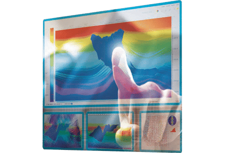
Intuitive Graphical User Interfaces and 3-D/4-D Visualization
- Intuitive graphical user interface for each module
- Base map viewer for input data and grid definition
- Beam and ray QC and visualization tools
- 3-D/4-D synchronized visualization, input data, gathers, stack, velocity model, travel times, base map
Innovative Seismic Solutions
- VTI and TTI anisotropy
- Orthorhombic anisotropy in Q4
- True amplitude consistency throughout all modules
- 3-D 360 degree wide azimuth tomography using extended gathers
- Diffraction imaging
- Topography
- Converted waves, OBC, VSP geometry
- Targets, grid of targets, sparse target lines
- Gamma migration scans
- Anti-aliasing: triangles, boxcar, multiple bandpass
- Optimization of data distribution on parallel nodes
- Job monitoring
- Node addition and removal during runtime
- Adaptive runtime parameter optimization
- PWD filter 5-D Beam Forming
- Slant Stack 5-D Beam Forming
- 5-D multiple dips detection
- Automatic Vrms estimation
- Single and multiple parameter residual velocity estimation
- Automatic or manual residual velocity picking
- VTI and TTI velocity updates
- Topographic updates
- Automatically generated back-projection points
- Layer freezing or global updates
- Global and local error visualization and QC