

DAWSON GEOPHYSICAL COMPANY
Houston, Texas, United States
DAWSON GEOPHYSICAL COMPANY
!


Leader in land seismic acquisition and processing.
About DAWSON GEOPHYSICAL COMPANY
At Dawson, we bring together six decades of land seismic acquisition and processing leadership with a focus on always doing what’s right for every client. In relationships, operations, safety and environmental stewardship, we work with the highest integrity to deliver as promised. We back our unrivaled knowledge of the land with leading technology and a comprehensive range of customized services to meet your every need. With Dawson, you get our total commitment in a total package.
Dawson’s comprehensive services are backed by a depth of knowledge of the land and its geology that is unmatched in the industry. As North America’s seismic solutions specialists, we bring together decades of industry experience and problem solving expertise to deliver the highest resolution images. Along with that expertise, comes industry-leading capacity to meet recording requirements in any environment, for any size client. Our skilled data acquisition crews work across every major basin in the U.S. and into Canada, ensuring environmental stewardship wherever we operate. All of which are more reasons why clients across the United States and Canada put their trust in Dawson.
Over 70 years of delivering on our word.
Founded in 1952 by L. Decker Dawson, Dawson Geophysical is a story rooted in Texas history and the pioneer spirit of the North American oil industry. That Dawson has become an industry leader with a reputation of delivering on its word is a testament both to the company's founding vision and ongoing management principles.
Starting with 10 employees some 70 years ago, Dawson has grown in crew count, and channel count, and has participated in key technological breakthroughs such as the transition from 2D to 3D seismic. In February of 2015, Dawson completed a strategic business combination with TGC Industries, Inc. a seismic data acquisition company with operations in the United States and Canada. As a result, Dawson has emerged as a leading provider in North America of onshore seismic data acquisition services with the most active number of field crews and largest channel counts today. Our seismic crews can be found throughout the producing basins of the Lower 48 states and in Canada, working from West Texas and South Texas to New Mexico, Oklahoma, Arkansas, the Appalachian Basin, the Fort Worth Basin, the Rocky Mountains and Alberta.
Through it all, we have stayed true to our values and our commitment of providing services with the highest integrity.
Description of Services
Our Services
The talent, tools and technologies to achieve your goals
Dawson has the people, the knowledge base, and the technology it takes to meet deadlines and achieve results in a way that is unsurpassed by any of our competitors. To satisfy your multiple requirements, we provide a comprehensive range of services that range from design and permitting to project management, surveying, field operations, maintenance, and data processing. Our people understand the geology, the operational issues, and use the most up-to-date technologies to cost effectively identify reserves. Simply put, on every key issue, you can depend on Dawson to provide what you need to reach your goals.
1). Acquisition Total Package
a). Planning/Design
In the planning/design phase of a 3-D survey, we begin by considering the geology of the rocks that are being imaged. Dawson geophysicists are involved with each survey design to ensure that the seismic acquisition parameters are optimized with regard to data quality and cost. Simply put, your geology is matched with the optimum survey design to meet your geophysical and geological imaging requirements.
To determine the appropriate design, we examine a range of rock properties, including:
- Depth
- Structural dip
- Rock density
- Rock velocity
- Reservoir complexity
Economic and implementation issues addressed include:
- Topography
- Vegetation
- Permits
- Roads
b). Project Management
From conception to completion, our experienced Project Managers oversee each phase of the project. Beginning with the Bidding process and extending to Permitting, Surveying and Recording, the Project Manager organizes all necessary requirements while staying in close communication with the client at all times.
The Project Manager:
- Evaluates the project area
- Assists the client with a design that meets the client’s objectives, efficiently and effectively
- Handles any legal, regulatory and permitting issues, HSSE concerns
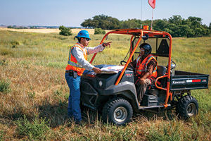
- Manages type of surveying method, type of source needed for the terrain, line clearing requirements and any special concerns that may be encountered by the Recording Crew
c). Permitting
Developing and maintaining direct dialog between the operating company and the landowner is critical to both the overall process and the success of the project. At Dawson, our permit team offers extensive knowledge of all aspects of permitting, surface and mineral title research as well as GIS mapping. These experienced permit agents understand and respect the rights and interests of landowners while also properly representing the interests of our clients at the same time.
d). Surveying
Our survey department consists of ten survey crews with approximately 10-15 staff per crew. We are in the process of adding more crews as properly qualified personnel are employed and trained. We also retain contract survey crews on an as needed basis. Our in-house survey crews are comprised of a Head Surveyor, Assistant Surveyor, and approximately six pack operators as well as one to three hazard mappers. We also have at least one TigerNav survey technician for each vibrator crew utilizing TigerNav Stakeless positioning technology. In the Midland Field Office we have a Survey Manager, Assistant Survey Manager, mappers and a lead TigerNav Survey Tech.
Survey and Mapping technologies include:
- The latest Trimble or Leica GPS/GNSS receivers capable of tracking all available civilian frequencies.
- RTK and Post Processing Software including Least Squares adjustment capabilities
- National Geodetic Survey’s OPUS (Online Positioning User Service) for Survey Control on a regular basis.
- The industry standard GPSeismic software is used for processing GPS/GNSS data In the field
- Multiple GIS quality GPS receivers/data collectors employing ESRI GIS software for access and hazard mapping
- MapInfo software for some mapping as well as ESRI ArcGIS software
- Base Mapping and Database integration handled by our GIS department located in the Midland Corporate office
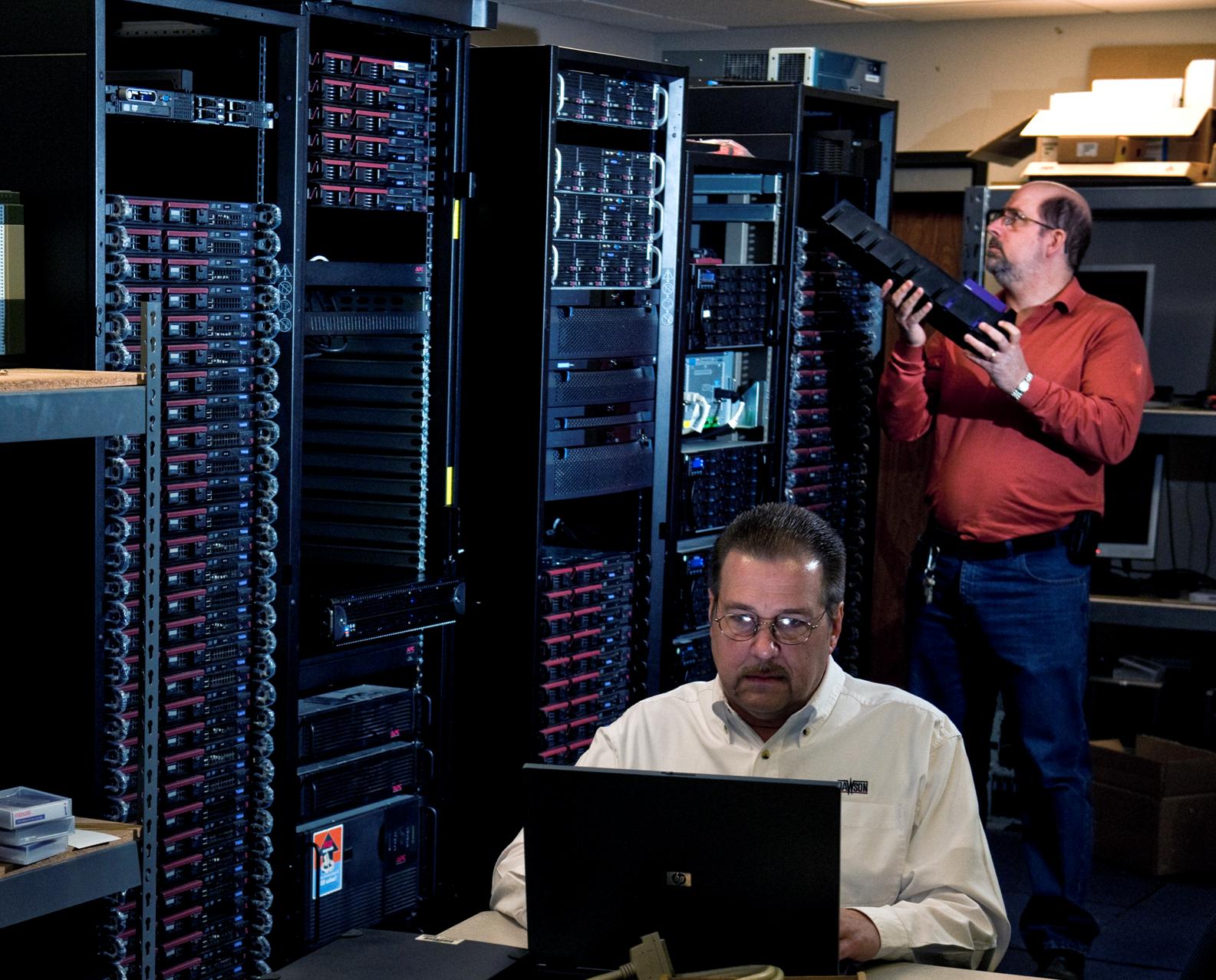
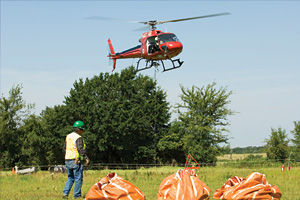
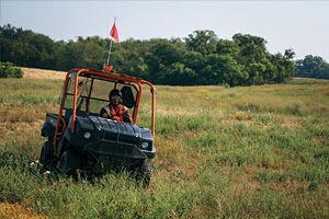
e). Field Operations
Dawson operates fourteen experienced crews of which four are equipped with ARAM ARIES recording systems, eight with GSR cable-less recording systems, one with wireless RT System 2 recording system and one INOVA Hawk recording system.
In the field, Dawson:
- Operates with a channel count of over 324,000 channels
- Equips crews with 62,000-pound peak force Vibroseis equipment and/or dynamite capabilities
- Positions source units by GPS
- Conducts stakeless surveys for our Vibroseis energy source utilizing Tiger-Nav
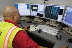
- Tracks all field units, including personnel carriers, in real time by GPS with helicopter support capabilities to minimize environmental impact and increase productivity
- Has 80,000 channels of GSR multi-component recording capability
- Operates real time microseismic surface monitoring
f). Support Services
Dawson's Support Services are here to help make sure your project goes smoothly and according to schedule. We offer a fully-equipped Ground Electronics repair facility staffed by professionals trained in box repair to respond quickly to any MRX, RSR or Aram box problems and maintain greater quality control. We also offer an electronics lab devoted to Source controllers. We have some of the best Field Service Engineers in the industry who are available on a moment's notice, to respond to any system or operational problem that may occur, as well as to handle normal job start-ups.
Dawson Support Services also includes:
- In-house design of proprietary software for every facet of crew operations management and support
- Electronic design capabilities
- Designing, fabricating and utilizing our own proprietary electronics equipment and techniques, such as Dawson GPS navigation equipment for our vibrators
- GPS tracking (Journey Management) of all vehicles and employees in the field in real time
- New techniques for data backup on all crews that allow instantaneous recovery from media malfunctions or losses in shipping.
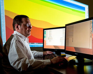
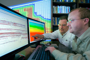
2). Processing
High quality images from even the most challenging data sets
Dawson is renowned for handling complex geology and tough statics areas. Our processing group is experienced in imaging data from all types of geologic regions and is dedicated to achieve quality results from even the most challenging data sets. We utilize an advanced team of processors that reliably images your objectives on schedule. And to assure the workflows, timeliness and imaging objectives are in line with your expectations, our geophysicists encourage client involvement throughout the life of the project. Whether it’s data processing or expert acquisition services, you benefit from a single point of accountability. You have our word on it.
Expertise
An unequaled depth and breadth of knowledge
Our unrivaled depth of knowledge of the land gives us a clear understanding the geology and how data should look going in, so we can produce accurate results coming out. We secure processing of 2-D and 3-D data, merge surveys and offer in-field processing for survey adjustments on the fly. To produce the clear images our clients need, we use advanced processing systems both in the field and at our processing centers. Exceeding expectations, keeping our promises. This is our mission.
Centers
Centers of Excellence
Processing since 1976, Dawson has centers in Houston, Midland and Oklahoma city. To produce the clear images our clients seek, we use the most advanced processing systems, such as the Pro-Max® processing system in the field. SeisUp® is the platform for production processing and Fusion’s seismic studio is the software used for refraction modeling. In addition, we offer advanced software in the areas of residual statics and pre-stack time migration.