

Ge OilEnergy
Calgary, Alberta, Canada
Ge OilEnergy
!


The world's best energy and technology solutions at your hands.
About Ge OilEnergy
We are a Colombo-Canadian service company with extensive experience in the Oil & Gas and Mining industries whose main distinction is the high quality and benefit in the products and services offered as well as extends the range of solutions, from on-farm workflows to production.
Founded in 2009 and with a team of professionals in Geomatics, Geophysics and Geology with over 100 years of combined experience Geo Oil Energy contributes to the execution of projects that exceed our client's expectations.
Geo Oil Energy is a Canadian and Colombian company specialized in providing technology solutions and services, consulting, and commercialization of state-of-the-art technology applications and services in the areas of: Geology, Geophysics, Geomatics and Engineering, providing our clients in Colombia and Latin America access to the best tools available internationally.
Description of Services
- Geospatial Solutions
Geo Oil Energy's team, along with its partner companies, provides the experience, and expertise in disciplines such as:spatial data acquisition, integration, management and automation, implementation of Geographic Information Systems (GIS), satellite image acquisition, radar, aerial photography and Light Detection And Ranging (LiDAR), automatic surface data extraction through the use of Artificial Intelligence (AI) and Machine Learning (ML), web mapping application (SIGOE), Software as a Service (Saas), among others; providing our customers with access to the latest technology to maximize the capture and use of your geospatial information.
- Geology Solutions
SURFACE GEOLOGY.
Geo Oil Energy is a company that provides multiple field geology services that allow the acquisition and collection of geological information for subsequent evaluation and analysis.
• Cartography, regional mapping and high detail mapping
• Structural geology
• Supervision, guidance and geological mapping for hydrocarbon exploration on field sections and seismic lines.
• Detailed/general stratigraphic column survey and rock sampling for further analysis.
• Outcrop characterization.
• Geochemical Field Sampling.
• Field sedimentology and stratigraphy
• Partners: PaleoGeo SAS
MANAGEMENT OF OIL&GAS EXPLORATION AND PRODUCTION CONTRACTS
Our company offers integral accompaniment to the companies managing the commitments of the exploration and production contracts signed with the government agencies, supporting the fulfillment of the contractual requirements related to the development of the contract, compliance with standards, reports, formats, integration of information, among others.
For companies that do not yet have or do not want to have their own software/technological infrastructure to develop their technical processes such as interpretation, database, GIS, reporting, etc. Geoil Energy offers a wide range of tools and infrastructure on site or in the cloud for the fulfillment of contract commitments or if it is the case to offer or evaluate oil&gas assets (E.g: data Room)
INFORMATION MANAGEMENT.
More than information management, we evaluate business processes and provide solutions that support decision making by accessing the information resident in different areas of the organizations in different formats and applications, allowing its visualization in unique interfaces with the information that is really needed, when and where it is required. We represent the world's leading software in integration, extraction, transformation and loading of spatial and non-spatial information. We migrate and load technical (e.g. geological/geophysical/geographic), spatial and non-spatial information between different applications.
SPECIALIST CONSULTANTS.
In addition to the conventional disciplines of evaluation of areas and/or prospects and fields, we have the representation of highly specialized companies in differential issues such as Chemostratigraphy, section balancing, among others.
- Geophysical Solutions
Lumina was founded by a team of highly recognize and qualified professionals with enviable success with clients ranging from small independent operators to super Majors and NOCs. Whether you’re starting an exploration program, looking for a Field development plan, or making a drill-or-drop decision, our unique technology and expertise can help you make the right choices.
SOFTWARE
Lumina Geophysical Software
Lumina’s desktop software brings state-of-the-art advanced seismic spectral and quantitative analysis capabilities to the desktop of every interpreter. These methods have been refined and proven through years of successful service work in Geologic settings all over the world, and are now available to the industry as applications designed for ease of use and integration with everyday geoscience workflows.
Prospectra®
Selected fundamental spectral analysis techniques are offered as plug-ins to the popular Petrel and DecisionSpace® interpretation platforms. Fast, flexible, and easy to use, Prospectra® is designed for today’s asset teams and scales to handle any size task. With Prospectra® you have access to unique and best-in-class tools for analyzing and interpreting your data, particularly suited for thin beds, critical fault analysis, and increasing the detail and accuracy of your reservoir characterization projects.
Leonardo™
Leonardo™ software is engineered for the future. It can be used to draw your 2D geological model more quickly, without having to set up complicated project and workspace. Leonardo allows users to save the model and generate the seismic responses in no time.
QI™
QI™ brings Lumina’s full suite of quantitative interpretation tools to the desktop as a standalone offering. In addition to the advanced spectral analysis capabilities offered in Prospectra®, QI™ provides a full suite of seismic conditioning, QC, visualization, pre- and post-stack inversion techniques, and multiple attribute analysis modules. QI™ will also be available as an integrated offering on popular interpretation systems in the near future.
SOLUTIONS
Expertise
We believe in working with you to understand your objectives, and in combining the best industry-standard products combined with our own unique world-leading technology to meet your business needs. We resolve your challenges. This highly-focused, quality-driven service has led our customers to work with us again and again. Our areas of expertise include the following:
- Information & Decision Support
- Seismic Analysis & Processing
- Integrated Studies
- QI Services
- Geochemical Solutions
Chemostrat is the world leader in chemostratigraphy and provides high quality stratigraphic services around the globe. The company is now at the forefront of a new revolution by creating a multi-disciplinary service matrix that incorporates a range of traditional and state of the art analytical and interpretative techniques that can be tailored to tackle a wide range of geological challenges focusing on providing cost effective and workable solutions for our clients.
Provenance – Sandtrak
The study of provenance within Chemostrat is handled by our specialised Sandtrak team. Sandtrak utilises various analytical techniques and the latest statistical and data treatment techniques to aid in the establishment of the provenance of a range of clastic sediments. These techniques include; high resolution heavy mineral analysis, high resolution sandstone petrography, zircon geochronology, feldspar geochemistry and other single-grain varietal studies, with these techniques being routinely integrated with the full inorganic element data suite acquired via ICP-OES/MS and with chemostratigraphic correlations produced from this data.
Correlation
Stratigraphic correlation is at the forefront of Chemostrat’s portfolio, with our signature chemostratigraphic services remaining very much the cornerstone of that portfolio. However, our unrivalled expertise in chemostratigraphic services is now complimented by an array of specialised stratigraphic services aimed at helping define chronostratigraphically-grounded correlation frameworks in the oilfield setting.
Reservoir Quality
Chemostrat has also established a work programme to integrate elemental and mineralogical data with petrophysical parameters to enhance reservoir quality modelling. For example, elemental data can also be used to calculate mineralogy and provide an estimate of TOC and proxy for relative brittleness (RBI) that following calibration ensures elemental data can be multipurpose, practical and more cost effective as a means of modelling which is critical for well completions in shale plays. Elemental data can also be used to refine the petrophysical modelling in carbonate plays detecting subtle variations in dolomite, anhydrite or salt that can hold the key to reservoir quality. Furthermore, mineral abundances can be measured from elemental data in turbo-drilled cuttings where textural mineralogical characteristics have been destroyed by the drilling process.
Shale Resource Plays
The shale gas revolution has only served to highlight the need to increase the understanding of shale composition and physical proprieties to improve exploration, drilling and production. Chemostrat is demonstrating the value of elemental data in shale resource applications, and our new service matrix can be applied to provide a bespoke shale service work programme that can be applicable to exploration, geosteering and completions optimisation. This work programme can be adapted for basin scale and involves chemostratigraphic and isotopic correlation, elemental mapping of anoxia, organic preservation, and terrigeneous input in conjunction with TOC and XRD data for basin evaluation. Furthermore, the acquisition of real time chemostratigraphic data at well-site can be employed to aid geosteering and the optimisation of field development with improved planning of targeted lateral wells.
Data Only
Uninterpreted raw geochemical and mineralogical can also be provided to meet your chemostratigraphic and reservoir modelling requirements. We can also accommodate custom requests for many different forms of analysis through our extensive range of contacts so please enquire about any requirements.
- Sustainability
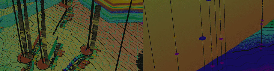
GHGSat is a private company on a mission to become the global reference for remote sensing of greenhouse gas (GHG), air quality gas, and other trace gas emissions from any source in the world.
In June 2016, GHGSat launched the world’s first high-resolution satellite capable of measuring greenhouse gas (CO2 & CH4) emissions from any industrial facility in the world. GHGSat is using this unique satellite and its patented technology to provide greenhouse gas emissions monitoring data and services globally,with better accuracy and at at a fraction of the cost of comparable alternatives. Some of the sites monitored by GHGSat are identified by orange dots in the image on the right.
GHGSat offers custom analysis, using GHGSat satellite imagery and other sources, on an exclusive basis to each customer, in much the same way as environmental consulting services are offered today. Examples:
• Monitoring of targeted sites (e.g. natural gas leaks from pipelines)
• Emission rate estimation, including inventory analysis emission rate of species, using single scene abundance dataset, for instantaneous measurements, or averaged over a full year.
Other products and value-added services are available from GHGSat on a case-by-case basis:
• Augmented analysis of emissions, using additional data such as facility data provided by facility operators
• Mosaics of commercial satellite imagery products
• Trending analysis of emissions from individual sites, or grouped sites in a region, within the constraints imposed by data exclusivity arrangements within individual customers
- Engineering Solutions
Started in Calgary, Alberta, Canada, we are the leading reservoir engineering service provider for oil and gas companies across Canada, US, Brazil, Middle-East and Australia. Our cutting-edge solutions optimize reservoir performance, hydraulic fracturing, flowback analysis and technical due diligence. Further enhance your operations with seismic services and reservoir characterization. Partner with us to revolutionize and develop your energy projects.
Introducing Athena, the cutting-edge platform to automate reservoir engineering workflows providing real-time data from the wellhead to your desktop. Athena is designed to perform automated production forecasting and economics bundled into an autonomous Evergreening process to deliver up to date oil and gas forecasts.
Flowback data analysis is designed to diagnose hydraulic fracture optimization efficiency right after fracking. When coupled with Real Time Frac Monitoring and Optimization, Athena delivers a revolutionary product to maximize oil and gas production from every well.
- Iraya Energies
The Earth is a treasure trove of data. Using AI-enabled and cloud native software, Iraya gathers and transforms unstructured data of the subsurface of the earth and surface facilities to find and produce the best sources of energy.
Data Atelier
The Data Atelier is a digital factory composed of pipelines orchestration, data tracking, and monitoring services. It provides an intelligent engine that runs the internal processes and machine learning algorithms in production. When optimized, it drives the cost of production down by ensuring economy-of-scale.
This proven process makes the Data Atelier one of the most powerful instruments in managing data today. It has built and assembled more than thousands of AI and AI management tools so that you can work faster and better while optimizing cost and performance.
ElasticDocs
Read the earth’s data better with ElasticDocs. Designed to enable engineers and geoscientists to browse through thousands of pages of reports in seconds and find geological analogs through sophisticated, pioneering search-and-cluster techniques engineered by Iraya’s team of machine learning specialists and geoscientists.
ED2Kr
All of EarthDoc’s 70,000+ articles are geotagged to 800+ geological basins around the world. Natural language processing, auto-image recognition, and recommender systems are fully integrated into the ED2K system. This results in a short amount of time, maximizing reading and analysis of the Earth’s data.
Using an intelligent pipeline of Optical Character Recognition, Deep Convolutional Neural Networks, Natural Language Processing & Knowledge Graphs algorithms, the machine auto classifies different earth image clues, from the macroscopic to the microscopic, so you, our earth scientists and engineers, can lead us to the right energy mix for the future.