

PXGEO
Houston, Texas, United States
PXGEO
!


To deliver sustainable seismic solutions for the world’s energy transition.
About PXGEO
PXGEO is an innovative marine geophysical service provider combining the strengths of ocean bottom node and towed streamer seismic data acquisition techniques to deliver seamless subsurface imaging for a sustainable future.
Our people are critical to successful service delivery to our clients and central to striving towards the PXGEO vision. We believe in empowerment and accountability of all employees, with a strong focus on learning and development.
In both onshore and offshore work environments our people will be supported to do their best, enjoy their day-to-day roles and progress both professionally and personally.
Description of Services
PXGEO offers the full suite of marine seismic data acquisition services leveraging the strengths of ocean bottom node and towed streamer methodologies. These high quality and efficient acquisition techniques are further optimized through our innovative seismic source solutions incorporating XArray™. PXGEO delivers its clients a bespoke acquisition solution to address their imaging challenges.
- OCEAN BOTTOM NODE
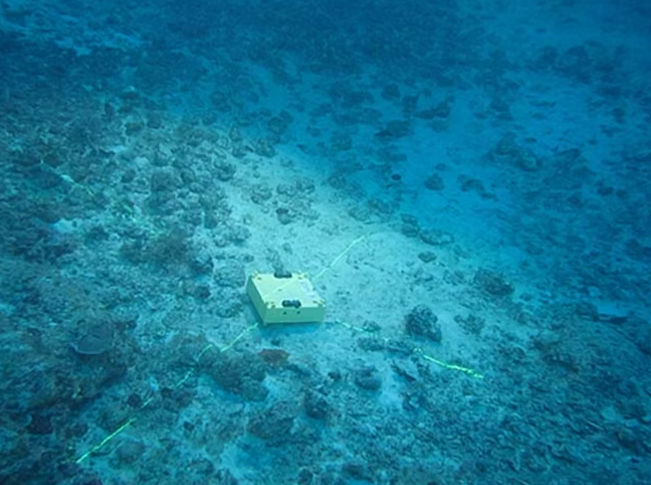
Ocean bottom node (OBN) acquisition is adaptable to more challenging imaging objectives providing full azimuth 4C sampling. PXGEO provides a range of ocean bottom nodes suitable in water depths up to 3,000 meter using efficient and accurate placement methods.
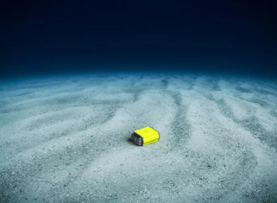
MANTA® OBN
Delivering improved efficiency and superior seismic data quality, MANTA® fully autonomous, multi-component OBN technology is designed to meet demands of all survey configurations to 3000 meters water depth.
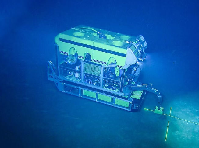
OPERATIONAL FLEXIBILITY
From semi-autonomous multi-ROV operations to node-on-a-rope, every PXGEO acquisition project is tailored to optimize operational efficiency and subsurface illumination using our wide range of technologies.
INNOVATING FOR THE FUTURE
As a leading provider of innovative seabed solutions, PXGEO is committed to the development and application of safe and efficient technologies available to the industry.
Our engineering team comprises of talented and experienced geoscientists, engineers and programmers who strive to meet client needs and deliver quality seismic data.
- TOWED STREAMER
Highly efficient and flexible 4D, 3D and 2D seismic acquisition methodologies, delivering narrow azimuth, wide-azimuth and multi-azimuth data sampling according to project specific imaging objectives.
STREAMER TECHNOLOGIES
PXGEO is utilizing Sercel Sentinel™ solid streamers, considered to be industry-leading in towed streamer acquisition combining the best signal/noise ratio with excellent low frequency performance, and outstanding reliability and longevity.
SEISMIC DATA MANAGEMENT
PXGEO’s Cirrus™ brings you closer to your seismic data, enables informed exploration decisions to be made in near real-time.
Cirrus™ is a suite of seismic data management services utilizing satellite streaming and processing in the cloud, designed to bring our clients better data faster and shortening the exploration cycle.
- FLEET
PXGEO operates a state-of-the-art seismic vessel with advanced maritime and seismic features and unique environmental capabilities to deliver superior seismic data.
PXGEO 2
14 Streamer Seismic Vessel
- HYBRID ACQUISITION
Acquisition solutions combining towed streamer and ocean bottom node techniques delivering seamless subsurface insights to address our clients most challenging imaging objectives.
SPARSE NODE GRIDS
Combining a sparse, passive node grid with high resolution streamer seismic data provides common receiver gathers with long offset refractions which are ideal input for full-waveform inversion and multi-azimuth reflections to address anisotropy.
TARGETED DENSE NODE PATCHES
Incorporating targeted dense node patches into a larger streamer survey complements the efficiencies of towed streamer surveys, with multi-component node data tailored to address specific imaging challenges.
NODE SWATHS FOR INFILL
For projects in congested areas with surface infrastructure and/or shallow water areas, node swaths provide seamless subsurface imaging where offsets from conventional dual vessel undershoots may not adequately illuminate targets.
- SOURCE TECHNOLOGY
Tailoring the energy source used for seismic acquisition surveys enables the desired imaging objective to be optimized. Typical energy sources contain an array of volumes to best match the geological environment.
OPTIMIZED SPECTRA
A standard energy source array will produce an acoustic broadband output with frequencies peaking between about 6 to 200 Hz.
To expand the signal bandwidth for both lower and higher frequencies PXGEO is utilizing innovative source technologies.
Using these technologies allows significant extension of seismic signal bandwidth for ocean bottom node and towed streamer surveys.
BLENDED SOURCES
Traditional use of marine sources required sequential activation of one or more sources as the survey vessel progressed down a selected acquisition line so that reflected signals from successive shots did not interfere.
With the recent development of robust data processing source de-blending techniques, multiple sources can now be activated in blended modes including overlapping in time or activated simultaneously. The use of blended multiple source techniques significantly increases 3D spatial sampling and trace densities while enhancing overall survey efficiencies.
PXGEO has a wide range of experience in towed streamer and ocean bottom node survey designs using blended energy source techniques.
MULTIPLE SOURCES
PXGEO's multiple source, XArray™ configurations provide improved in-line shot intervals and cross-line bin density on any streamer separation. These can be tailored to provide higher fold data, increase cross line sampling and/or improve acquisition efficiency.
This is achieved using multiple sources, continuous data recording and ‘deblending’ algorithms to separate energy from overlapping shots.


What we do
APPLICATIONS
- 3D EXPLORATION
Highly efficient, large scale 3D seismic data acquisition is adapted to meet geological-specific imaging objectives. Flexible streamer, OBN and source configurations can provide high resolution 3D spatial sampling with high trace densities in both offset and azimuth.
PXGEO has a wide range of experience working with clients to optimize their exploration objectives in areas such as the Gulf of Mexico, West Africa, Europe, Mediterranean, South America and Asia Pacific.
- 3D APPRAISAL AND DEVELOPMENT
Focused 3D seismic data acquisition in producing basins targets specific imaging objectives. OBN and streamer configurations can be combined to address specific imaging challenges while optimizing broader basin-wide geological understanding.
PXGEO works closely with clients in a number of producing basins worldwide including in Brazil, Australia, Asia Pacific, the North Sea and Norway to provide key insights to their appraisal and development activities.
- 4D PRODUCTION OPTIMIZATION
Repeated high resolution data acquisition enables the measurement of incremental subsurface changes over time. Enhanced applications of towed streamer and OBN techniques are particularly suited to complex geologies and obstructed areas.
PXGEO has extensive experience working with clients to optimize hydrocarbon production in such geographies as Brazil, West Africa and Asia Pacific.
- CARBON CAPTURE, UTILIZATION & STORAGE
Advanced subsurface imaging provides valuable insight for offshore Carbon Capture utilization and Storage (CCUS) strategies. CCUS is becoming increasingly important to mitigate the impact of greenhouse gas emissions.
PXGEO has experience in working with clients and governments to address their CCUS strategies in countries such as Norway, Japan, UK and Australia.
- OCEAN BOTTOM SURVEYING
Advanced subsurface imaging brings crucial insights for such applications as deep sea mining (DSM) projects, ultra high-resolution hazard surveys and ocean floor mapping.