
Subsurface Clarity
Magnolia, Texas, United States
Subsurface Clarity
!


Seismic Interpretation Expertise and Technology.
About Subsurface Clarity
Subsurface Clarity was created in February 2017 with the goal to bring state-of-the-art 3D seismic data interpretation expertise and technology to small and medium-sized companies. We have licenses for both the GeoTeric® and PaleoScan™ software suites which provide us with advanced data analysis and interpretation tools. The integrated workflows allow us to create very detailed subsurface products within greatly reduced cycle times.
Our work covers both conventional and unconventional targets, at either the regional or reservoir scale.
Description of Services
FOCUSED ON RESULTS
Subsurface Clarity is a seismic data interpretation company specifically designed to generate integrated products aimed at the 3-dimensional nature and distribution of your reservoir targets; and at reducing your project cycle time.
In today’s data-rich and increasingly highly-specialized technical environment, we provide interpretation expertise and leading-edge technology to companies of any size.
Advanced software suites allow us to produce.
Visualization
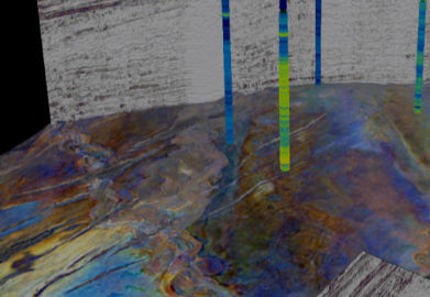
We use 3D visualization, not only for scrolling through very large seismic data volumes and viewing final products, but as an integral part of our interpretation process. For instance, visualization is an important step in our multi-attribute seismic facies analysis, well and seismic data cross plots, color blending, volume rendering and geobody workflows.
Through a careful blend of expertise and technology, we integrate complex data sets to produce data-consistent interpretations.
Uniquely applied
3D seismic data volumes can be quite variable in terms of vintage, frequency content, and data quality. Our interpretation workflows therefore start with noise cancellation and frequency enhancement steps where appropriate. These steps are followed by the creation and editing of a 3D grid where every peak, trough, and zero crossing are used to generate a 3D model grid. This level of detail allows us to move quickly to sequence analysis and to focus our attention, very early on, to the depositional styles present within your target intervals, i.e., whether non-marine, shallow-marine, and/or deep-marine.
What we do
Services:
- Interpretation products
We apply integrated workflows based on the GeoTeric® and PaleoScan™ software suites that allow us to take post-stack seismic data volumes from noise cancellation to 3D property modeling.
Project deliverables are determined by your company’s subsurface targets and objectives, and are created in close collaboration with your teams. Our capabilities include a wide range of expertise:
- PRE-CONDITIONING to enhance the S/N ratio (noise cancellation, spectral enhancement)
- STRATIGRAPHIC INTERPRETATION to detect and analyze your targets (HD Frequency Decomposition, RGB blending and visualization, detailed horizon mapping)
- WELL DATA INTEGRATION for well-log correlation and interpretation, well-to-seismic ties, and Well Marker QC
- SEQUENCE STRATIGRAPHIC ANALYSIS to reconstruct the basin evolution (Wheeler diagram construction and the integration of chrono-, litho-, and seismic-stratigraphy)
- 2D INTERPRETATION to create 3D geomodels from conditioned 2D seismic line sets
- SEISMIC FACIES INTERPRETATION to predict reservoir trends and distribution (Interactive seismic facies volumes, Attribute cross plotting, Color blending and visualization)
- FAULT VISUALIZATION AND INTERPRETATION for major and minor structural trends (Faults and edge-detection attributes, CMY blending and visualization, adaptive fault interpretation, detailed mapping on to horizons)
- 3D PROPERTY MODELING to propagate well-log data, cokrigged with facies and attribute volumes, throughout our 3D Geomodels
- 3D GEOCELLULAR MODELING to generate Eclipse-compatible geocellular models, populated with well-log based petrophysical properties
- COLLABORATION/STRATEGIC ALLIANCES
- Through collaboration with independent consultant Somanath Misra, we are now able to provide a full suite of post-stack seismic inversion products
- We also have a strategic alliance with SEB Solutions who are able to take geocellular grids generated from our 3D seismic data workflows through detailed Geologic Reservoir Modeling.
2. Mentoring & Technology Transfer
Ken and Clémence both bring extensive experience in technology transfer and mentoring to your teams. While working with Eliis, Clémence was responsible for both public and in-house PaleoScan training. Ken teaches 3D seismic data interpretation as part of the Professional Science Master’s program at Rice University, where he has been an adjunct professor since 2017.
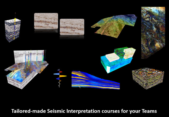
Courses can be designed around your project data sets, and tailor-made to cover your team’s specific 3D seismic data interpretation needs. Class sizes can be kept small, with meeting dates and times chosen to fit the participants’ work schedules. Class formats can be in-person, or online.