Consultation - Geotechnical Investigation

Share
Description of Consultation
1. DC-Geoeletric
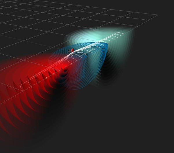
A geoelectrical measurement is carried out by recording the electrical potential arising from current input into the ground with the purpose of achieving information on the resistivity structure in the ground. In a homogeneous ground (halfspace) the current flow radially out from the current source and the arising equipotential surfaces (red surfaces) run perpendicular to the current flow lines (blue lines) and form half spheres.
Applications
- Mineral exploration
- Groundwater
- Geophysical-Archaeology
- Cavities detection
- Geotechnical Investigation
2. Ground Penetrating Radar (GPR)
Ground-penetrating radar (GPR) is a geophysical method that uses radar pulses to image the subsurface. This nondestructive method uses electromagnetic radiation in the microwave band (UHF/VHF frequencies) of the radio spectrum, and detects the reflected signals from subsurface structures. GPR uses high-frequency (usually polarized) radio waves, usually in the range 10 MHz to 2.6 GHz. A GPR transmitter (Tx) emits electromagnetic energy into the ground. When the energy encounters a buried object or a boundary between materials having different permittivities, it may be reflected or refracted or scattered back to the surface. A receiving antenna (Rx) can then record the variations in the return signal.
3. Borehole seismic survey; Down- and Cross-Holes
What you will get from meeting with me
Consultation - Geotechnical Investigation
Things I can do. Things I can offer
Consultation - Geotechnical Investigation
My Classification
Renewable Energy Company,Energy Service Company,Mining Service Company,Engineering Company,Consulting Company,Contractor,Sub-Contractor
My Experience Level
Senior

About 3D Consulting-Geo GmbH
3D Consulting-GEO GmbH is a registred company based in Berlin, Germany. 3D Consulting-GEO and international partners aim at providing high-quality solutions in geophysical and geotechnical studies.
Ratings & Reviews
No Ratings & Reviews given yet..
More Consultations From 3D Consulting-Geo GmbH

Consultation - 3D INVERSION OF MAGNETOTELLURICS (MT) DATA

3D Consulting-Geo GmbH
500/hr
Similar Consultations (Recommended consultations)


National Engineering Services Pakistan (Pvt.) Limited (NESPAK)
1000/hr

GEO LINE SOLUTION
400/hr


National Engineering Services Pakistan (Pvt.) Limited (NESPAK)
1000/hr


